This article first ran in the May issue of Bicycle Retailer & Industry News
BOULDER, Colo. (BRAIN) — Simple Cycling Maps, a company that designs hyper-local cycling maps, full-scale map murals, and custom print/digital assets, recently completed a bike park trail map of Idaho Springs, Colorado. Founded by Michelle and Zach Lee, the company is also developing a Walk/Bike Map for nearby Golden, Colorado, and expanding beyond Colorado with an OZ Trails Bike Park Map project in Bentonville, Arkansas.
“We’re cyclists first and designers second. And Simple Cycling Maps grew out of our own need for a clearer way to see the roads, levels of difficulty for climbs, and connections that cyclists in Boulder actually use. Our options were outdated paper maps or Strava heat maps. There was nothing in between to help average cyclists. So my husband, Zach, started sketching a map that filled the gap in an analog way and removed some of the bias the tech has,” said Michelle, who has a background in architecture, urban design, adaptive reuse, and business operations. “In 2016, Zach launched Simple Cycling Maps with the Boulder bike map.”
From pocket-sized maps to wall-sized climb compares
A cartographer with a background in branding, environmental graphics, and installations, Zach then designed the first climb-compare visual to show how the Tour de France’s Stage 12 final climb, Alpe d’Huez, compared to Boulder-area climbs including Flagstaff. This evolved into the profile series, a side-by-side, comparative view of different regions’ most challenging ascents.
By the end of 2016, Simple Cycling Maps debuted the Boulder System Map. Based on collective knowledge from cycling communities, system maps highlight clear routes and cyclist-specific destinations.
“To move Simple Cycling Maps forward, we worked with SRAM, which funded the printing of pocket maps for Boulder and the Santa Monica Mountains,” said Michelle of the foldable, waterproof paper maps. Rapha Boulder Clubhouse (which closed in March) was the first retail partner to carry the Boulder Pocket Maps, followed by Boulder’s Art Source International, University Bikes, and Skratch Labs’ Table café.
The maps are oriented with the west, instead of north, to the top, in line with how Boulder-area cyclists orient themselves, since the Colorado Front Range runs north to south. Key cycling routes are arranged something like a transit-system map for simplicity.
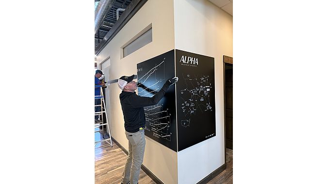
In 2023, Simple Cycling Maps collaborated with Cory Pomerantz on the Santa Monica Mountains’ Pocket Maps, which were first available online and at Rapha Los Angeles. The maps can now be found at Pedalers Fork, The Hub Westlake, and other retailers in California. By 2024, Simple Cycling Maps caught the attention of Specialized, which commissioned Zach to create a 30-foot mural at its Innovation Center in Louisville, Colorado. 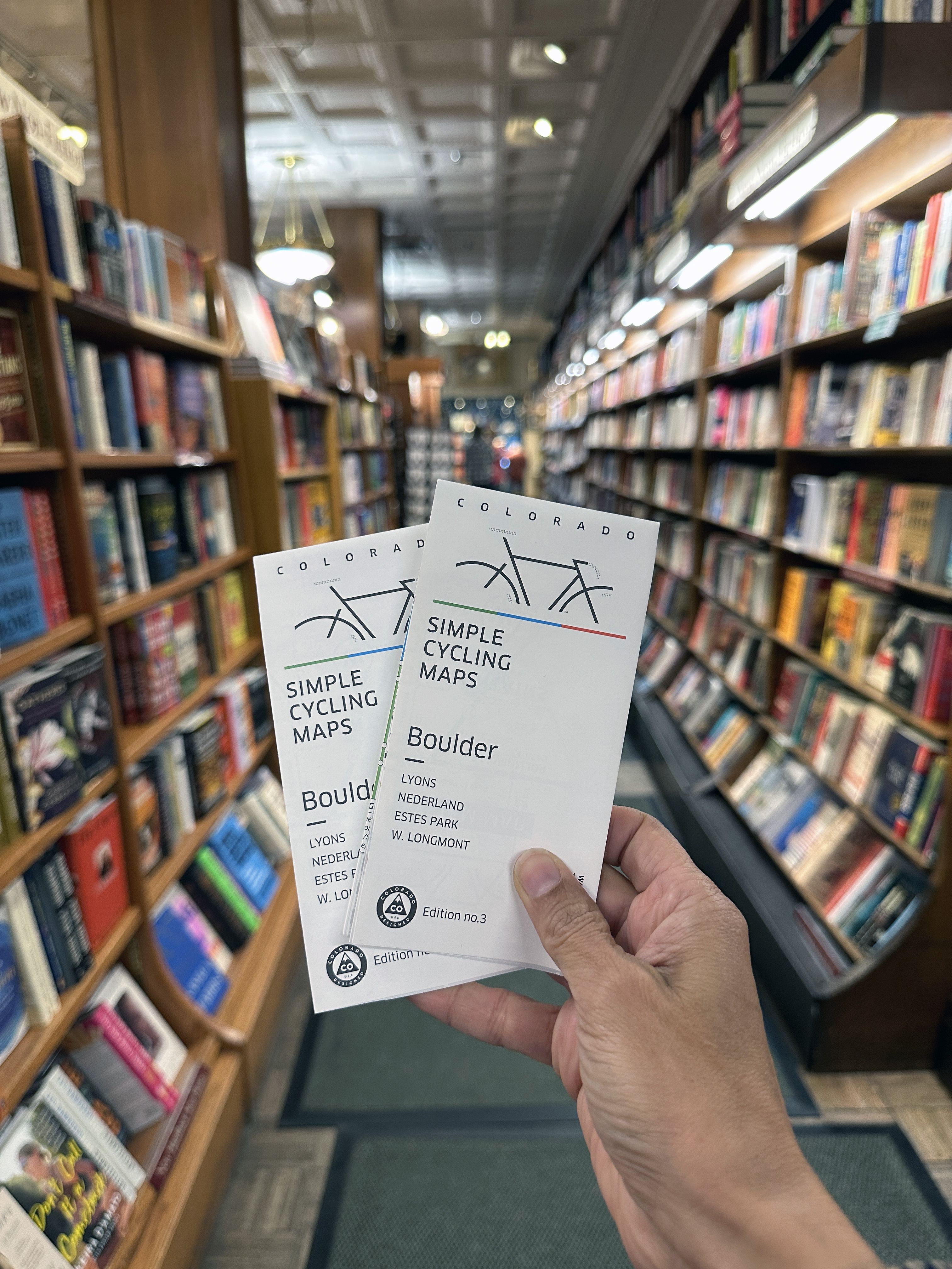
“Clients commission us to design climb-compare prints with their requested ascents and stops,” said Zach. “For the Center, we transformed one of the walls into a visual narrative through a wall-sized climb compare.”
Last year, Simple Cycling Maps unveiled its Colorado Climbs Profile Series, a comparison of 36 gravel and road climbs printed on a rolled poster, foam core, or sleek metal. And its new Virginia Canyon Mountain Park Map project is focused on that area’s mountain bike trails. Funded and commissioned by Colorado Mountain Bike Association, the project coincides with the opening of the Mighty Argo gondola in Idaho Springs, bringing mountain bike riders lift access to the trail system this spring.
Reinforcing a shop’s foothold in the community
In January, the Lees officially left their full-time jobs in their respective design fields to take Simple Cycling Maps from a self-funded, personal project to a company that helps cities, non-profits, bike park developers, retailers, and advocacy organizations easily communicate routes and networks. “The Golden Bike/Walk Map we’ve been developing is a good example. People want a map that helps them ride safely around Golden on any type of bike,” said Michelle. To produce the community-centered cycling map, the non-profit advocacy group Bike Walk Golden is bringing in corporate and institutional sponsors to help fund design fees. 
The Lees’ map design process includes analyzing neighborhood-to-neighborhood connections, lower-stress routes, trail access, and everyday mobility. The couple created the Simple Cycling Maps Strava Club, enabling cyclists to help shape the new map by sharing favorite loops, concerning intersections, sites to see, and spots to avoid.
The Lees have also been working on a map for Arkansas’ first chairlift-served mountain bike park, OZ Trails Bike Park, which opens on June 12. Runway Group, the holding company behind the park’s development, commissioned Simple Cycling Maps to create the analog map.
“Custom map installations and route murals can help bike retailers and cycling-related spaces tell a stronger local story and create a more memorable in-person experience. The Rapha Boulder Clubhouse is an example of that. Runway Group reached out to us after seeing our maps at the clubhouse,” said Zach. “Alpha Bicycle Studio is another. They sent us a list of where their customers love to ride and we created a two-wall climb-compare and key map mural mounted on metal. It’s a practical yet striking way to display data and reinforce a shop’s foothold in the community.”
“We’ll always have our D2C site for custom orders and art pieces, but people don’t tend to visit our site to buy the pocket maps. The maps retail for $10 and most customers prefer to buy them from their local shop rather than pay shipping for the online order,” Michelle said.
“Pocket maps offer something cyclist-specific, visually distinctive, and giftable. As Simple Cycling Maps has expanded beyond Boulder and into new map projects, that combination of utility, design, and connection to place has been an important part of how we think about the business.”
More information: simplecyclingmaps.com.

-
-

-
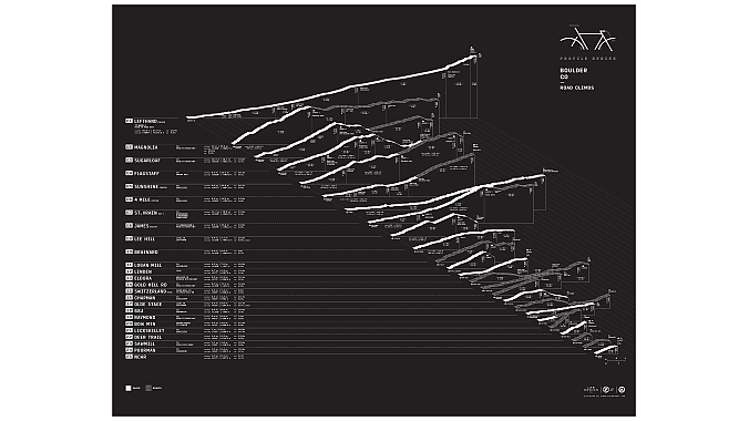 Profiles of some major climbs in the Boulder area.